 We welcome and are well prepared for fully customised fly-in tours during daylight hours; even if you just want to call in and say ‘Hi’ and enjoy a cuppa.
Our grass-covered landing area is located in the paddock immediately to the west of our house and it’s easy to taxi to our house yard access gate.
The strip is mown regularly to keep the grass short, and is also grazed by our stock from time to time – which we move into adjacent paddocks when giving authority to land and in line with our farm grazing plan.
The length of the landing area is 803 metres measured between the two standard stock fences on either end; or 773 metres after adjusting for the fence heights of approximately 1.2 metres. The runway width (mown area) is 15 metres. There are 400 mm square white flush-with-the-surface markers on both sides of the runway every 80 metres; and prominent end markers in place. There are no power lines within 1.5 km of the runway.
The following is a diagram of the paddock containing the airstrip. It shows various aspects of relevance to pilots.
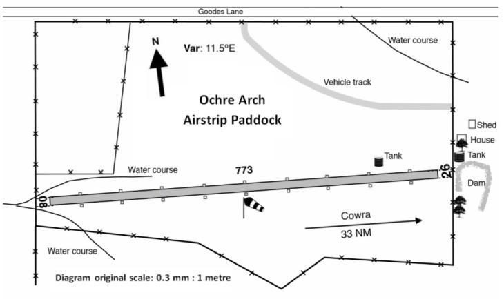
The average width of the paddock is around 500 metres. The paddock width at the western end is approximately 45 metres.
Our landing area is listed in the NSW Country Airstrip Guide. This link enables you to download a copy of our listing as at 2016. Airservices Australia has allocated us a ‘Y’ code of YOCA and our Fact Sheet is included in the En-route Supplement Australia (ERSA).
The following image was taken with a quad-drone looking east from over the western approach to and along the runway. The yellow lines are an approximation of the paddock boundaries and runway edges shown in the foregoing diagram.

The landing area elevation and slope varies gradually and:
- at the western end the elevation is approximately 1,017 feet (310 metres)
- at the highest point (640 metres from the western end) is 1,059 feet (322.8 metres) meaning a rise of 42 feet (12.8 metres) giving a longitudinal slope from the western end of 2 %
- at the eastern end (which is 160 metres from the highest point) is 1,051.5 feet (320.5 metres) meaning a fall of 7.5 feet (2.3 metres) over the 160 last metres and an overall slope for the runway of 1.31 %
Putting the slope in “pilot-speak” if approaching from the western end of the landing area: “from the western end there’s a 2.5% up-slope leveling off over the next 640 metres to the knee, and then a 1% down-slope to the eastern end of the runway”.
The transverse slope of the runway varies gradually from zero (0) at the western end to a maximum of 2.87 % at 560 metres from the west and then reducing to 2.5% at the end.
The GPS coordinates for landing area at the:
- eastern end are South 33° 45.342’ (33 45 20.5) and East 148° 00.862’ (148 00 51.5)
- highest point are South 33° 45.342′ (33 45 20.5) and East 148° 00.764′ (148 00 45.8)
- central point are South 33° 45.336’ (33 45 20.1) and East 148° 00.601’ (148 00 36.1)
- western end are South 33° 45.327’ (33 45 19.5) and East 148° 00.340’ (148 00 20.4)
The is one windsock located about half way along the land area and about 12 metres south of the southern edge of the mown area. The predominant wind direction in our ‘neck of the woods’ is south-westerly.

The image below from Spatial Information Exchange is of the paddock where the landing area is located together with both approaches. The blue line is the runway and the red lines are the approaches. The vertical lines at the end of the approaches is an approximation of 5 % at 900 metres.

NB: The old fence that appears in the above image about 150 metres from the western end of the landing has been removed since the image was taken, as has one of the large trees immediately to the south of the eastern end of the runway.
We’ve a dedicated area that we mow between the eastern end of the landing area and out the front of our house that a serves as a parking area for group visits.

The point-to-point distances to our place from various airports are approximately:
- Albury – 144 nautical miles (NM)
- Bankstown – 148 NM
- Bathurst – 86 NM
- Camden Airport, Cobbity – 132 NM
- Canberra – 110 NM
- Cowra – 33 NM
- Dubbo – 97 NM
- Forbes – 24 NM
- Nowra – 154 NM
- Orange – 60 NM
- Parkes – 39 NM
- Temora – 48 NM
- Wagga Wagga – 87 NM
- Young – 32 NM
The Common Traffic Advisory Frequency (CTAF) for Cowra, Forbes and Parkes airports is 126.7 MHz.
We don’t charge landing or parking fees but of course welcome donations to assist with the cost of maintaining the landing area. We do charge for tours, meals and ‘cuppas’.
If you’d like to arrange a visit just give us a call on 0425 760 596. We can also refer you to others who have experienced our landing area.
