Directions: A Google Place map is below followed by:
- written directions to the farm from Barmedman, Grenfell and Forbes
- written directions and maps to the farm from Orange and West Wyalong.
GPS Coordinates for the farm entrance gate are below:
South: 33 45.198 East: 148 00.904
Directions from Barmedman to Ochre Arch
- From Barmedman take the Mary Gilmore Way / Barmedman Grenfell Road and proceed for 32 km just through Morangarell
- Veer left into Euroka Road / Morangarell Road aka Morangarell / Quandialla Road and proceed 17 km to Quandialla
- On reaching the Mid Western Highway in Quandialla turn right / east, cross the railway line and proceed for 3.6 km
- Turn left into Driftway Road and proceed 18 km
- At the Mid Western Highway turn right and proceed for 10 km
- Turn left into Piney Range Hall road and proceed for 6.6 km
- Turn left into Pinnacle Road and proceed for 4 km
- Turn right into Goodes Lane and proceed for 2.3 km
- Enter the Ochre Arch entrance gate on the right and proceed for about 300 metres to the house.
Directions from Grenfell (from the roundabout near the Weddin Shire Council administration building – Corner Camp and Weddin Streets):
Sedans:
- Take the West Wyalong Road / heading west from Grenfell for about 9 km
- Turn right (north) and proceed toward Forbes along the Henry Lawson Way for about 8 km
- Immediately after crossing the Goonumburrbung Creek turn left (west) into Goodes Lane (good quality gravel road) and proceed for approximately 8 km
- Entry gate to the farm is on the left and is signed “Ochre Arch”. Mailbox has a red arch over it.
- Proceed along the farm track (in good condition) and park near the house
Buses, Caravans, and Motor-homes
- Take the West Wyalong Road / heading west from Grenfell for about 9 km
- Turn right (north) and proceed toward Forbes along the Henry Lawson Way for about 4.8 km
- Immediately after crossing the Ooma Creek at Nags Head Bridge turn left (west) into Pinnacle Road and proceed for approximately 13.6 km
- Turn right into Goodes Lane and proceed for 2.3 km
- Entry gate to the farm is on the right and is signed “Ochre Arch”. Mailbox has a red arch over it.
- Proceed along the farm track and park near the house
Directions from Forbes:
Sedans
- From Forbes head out the Newell Highway towards West Wyalong
- Shortly after crossing the Lachlan River on the outskirts of Forbes take the first left (south) onto the Wirrinya Road
- Proceed for approximately 42.5 km. NB: About 19 km from the above intersection you will cross the railway line at Garema. Proceed straight ahead. At this point the road becomes Pinnacle Road
- Turn left (east) into Goodes Lane (quality gravel road) and proceed for 2.3 kms
- Entry gate to the farm is on the right and is signed “Ochre Arch”. Mailbox has a red arch over it.
- Proceed along the farm track (in good condition) and park near the house
Buses, Caravans, and Motor-homes
If coming from Parkes into Forbes:
- After crossing the railway line, turn left at the traffic lights along Newell Highway / Sheriff Street and proceed for 0.9 km
- Turn left at the Shell Service Station into Camp Street towards Cowra / Grenfell and proceed for 650 metres (road crosses the bridge)
- Turn right at the roundabout into Flint Street and proceed for 1.3 km
- Turn left into Reymond Street and proceed across the Lachlan River bridge and follow the road as it veers to the right and becomes the Henry Lawson Way.
- 1.7km after crossing the railway line turn right (south) towards Grenfell staying on the Henry Lawson Way
- Travel approx. 40 kms and turn right (west) into Mortray Road and proceed for approximately 10 km. NB: The Mortray Road turn-off from Henry Lawson Way is not far past the Bald Hill Road turnoff (on your left).
- Turn left (south) into Pinnacle Road and proceed for 5 kms.
- Turn left (east) into Goodes lane (a good quality gravel road) and proceed for 2.3 km
- Entry gate to the farm is on the right and is signed “Ochre Arch”. Mailbox has a red arch over it.
- Proceed along the farm track (in good condition) and park near the house
Those intending using the camping site:
Entrance to the camping area is via double gates on the right approx. 2kms along Goodes Lane from Pinnacle Road. Enter through the gates, go straight ahead along the farm track for about 30 metres and then turn right and select a site adjacent to the large trees in the paddock on your right.
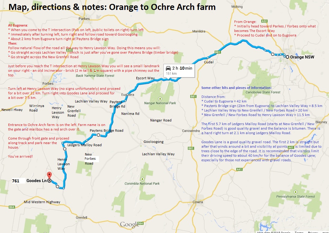
Map incorporating directions from Orange – for sedans
Buses, Caravans, and Motor-homes travelling from Orange
We recommend that you travel to the farm via Forbes or Grenfell rather than Eugowra and Ledgers Molloy Road.
Directions from West Wyalong and map:
- From West Wyalong head north east along the Newell Highway toward Forbes (and Grenfell) for about 36.5 km (measured from corner Church and Main Streets in West Wyalong)
- Turn right (east) towards Grenfell onto the Mid Western Highway. This intersection is not far past the large ‘Safety Camera’ frame that spans the highway.
- Proceed along the Mid Western Highway for approximately 45 km. NB: About 24 km from the above intersection the road goes through the village of Caragabal.
- Turn left (north) onto Piney Range Hall Road (also sign-posted “Pinnacle 18”)
- Proceed for 6.5 km to the T intersection where you will see the signs “Pinnacle Road” and “Forbes 50”
- Turn left (north) at the above intersection and proceed toward Forbes along Pinnacle Road for 4 km
- Turn right (east) at Goodes Lane (quality gravel road) and proceed for just over 2 km
- Entry gate to the farm is on the right and is signed “Ochre Arch”. Mailbox has a red arch over it.
- Proceed along the farm track (in good condition) and park near the house
A map showing the above route is below.
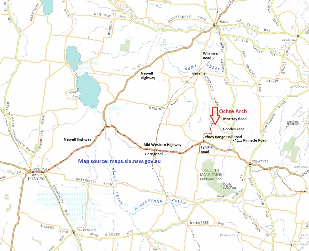
Map from West Wyalong to Ochre Arch
